
New technologies used to identify biodiversity
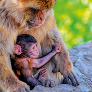
Using environmental DNA, such as urine, faeces, blood and saliva, the team can identify the different species inhabiting an area.
Researchers from the Universities of Leicester and East Anglia are using a combination of satellite and ground data to determine decreasing monkey populations, as a result of hunting. The team, led by Professor Heiko Balzter of the National Centre for Earth Observation at the University of Leicester, has been testing a range of technologies, to assess the number of living species in an area and the potential risks they might face.
Scientists have collected a variety of data, including human activity and settlements, mosquito-based iDNA, animal sound recordings, and the detection of other large vertebrates. The aim in collecting this data was to establish monkey distribution and to identify where populations might be most at risk.
Professor Balzter explained: “There are ten times as many satellites in operation now as there were in the 1970s. Most people now use maps from Earth Observation on their mobile, such as Google Earth. The European Copernicus satellites now provide free global data every 5 days at 10m resolution. And think of small cube satellites that fit into a tote bag and weigh only 2kg. Satellite technology has undergone a massive change and has never been so accessible.
“However, satellites cannot observe small animals directly. Most biodiversity is invisible to a satellite.
“Scientists have developed indicators for biodiversity, such as land cover type, and modern ecological models that can digest satellite data and information on species occurrence are now offering near-real time monitoring of the land management impacts on biodiversity. We propose using a mix of new technology rather than a single remedy.”
One of these new technologies includes ‘high-throughput DNA sequencing’ which can be defined as ‘en mass’ genetic fingerprinting. Using environmental DNA, such as urine, faeces, blood and saliva, the team can identify the different species inhabiting an area.
In addition to this, scientists use traps to collect bulk samples of organisms, such as mosquitoes. These samples are blended into a ‘biodiversity soup’, where the blood from the animals (fed on by the mosquitoes) can be analysed. The team also used automatic recording devices to record and profile the different animal sounds in an area.
The range of information collected through these methods, as well as the satellite interpretations, provides an abundance of biodiversity data.
Professor Douglas W. Yu from the School of Biological Sciences, University of East Anglia, who co-led the research, said: “DNA-based methods are a powerful way to relieve the taxonomic bottleneck in biodiversity assessment, but they are only partially able to relieve the sampling bottleneck. In the end, the only way to cover whole landscapes is to combine satellites, sequencers, and statistics.”
Professor Balzter added: “It may sound like a strange idea - satellites that can see the genetic make-up of the blood sucked by mosquitoes. Of course they cannot directly see that. But big data from genetic fingerprinting of animal DNA in a landscape combined with fine-resolution satellite data and sophisticated ecological models can. We need to work across subjects to make this happen. These are very exciting times. If our research can help to save a species that gives me a very strong sense of purpose to my job as a university professor.”
Due to the number of species now at risk of extinction, the UK has joined the United Nations Convention on Biological Diversity. In 2010, the convention established a set of targets that aimed to tackle the causes of biodiversity and ease the pressures associated with it. In addition to this, the targets pledged to better protect ecosystems and species, whilst boosting the benefits of biodiversity and ecosystems. Lastly, the convention vowed to support participatory planning, capacity building and education surrounding the topic.
The full paper, titled ‘Connecting Earth Observation to High-Throughput Biodiversity Data’ is published in the journal Nature Ecology and Evolution.

 Defra has published guidance for the vet sector ahead of a proposed UK-EU Sanitary and Phytosanitary agreement.